+91-9622371850 apekshaadventure@gmail.com
Best Seller
From₹14,000₹11,000
Booking Form
Enquiry Form
Full Name*
Email Address*
Travel Date*
People*
Your Enquiry*
* Creating an account means you're okay with our Terms of Service and Privacy Statement.
Please agree to all the terms and conditions before proceeding to the next step
The tour is not available yet.

Proceed Booking

Save To Wish List

Adding item to wishlist requires an account

3556

Why Book With Us?

  • No-hassle best price guarantee
  • Customer care available 24/7
  • Hand-picked Tours & Activities
  • Friendly and knowledgeable staff

Get a Question?

Do not hesitage to give us a call. We are an expert team and we are happy to talk to you.

+919622371850,+917456877193

apekshaadventure@gmail.com

The Source of the sacred Ganges..

Gomukh, also known as “Gaumukh” or “Gomukhi” (Hindi: गौमुख or गौमुखी ; Assamese and Bengali: গোমুখ or গোমুখী), is the terminus or snout of the Gangotri Glacier and the source of the Bhagirathi River, one of the primary headstreams of the Ganga River. The word Gomukh/Gaumukh (go/gau=cow, mukh= mouth) literally means “Mouth of a Cow.”

The place is situated at a height of 13,200 ft (4,023 m) in the Uttarkashi district in the state of Uttarakhand, India. It is one of the largest glaciers in the Himalayas with an estimated volume of over 27 cubic kilometers.

It is a Hindu holy pilgrimage site, visited by many who visit Gangotri. It is around 20km away from Gangotri and can be reached by trekking.

Package Highlights

Visit the sacred Gangotri Temple.
Trek to the source of sacred Ganga River – Gaumukh Glacier
Camp at the foot of celebrated Himalayan peaks.
Small batch size with freedom to explore more


apeksha@adventure

Gaumukh Trek (Source of Mother Ganges)

0
  • UttarakhandRegion
  • Gangotri to GangotriDistrict
  • 4 Days / 3 NightsDuration
  • ModerateDifficulty Level
  • 4255mHighest Altitude
  • 36 KilometersTrekking Distance

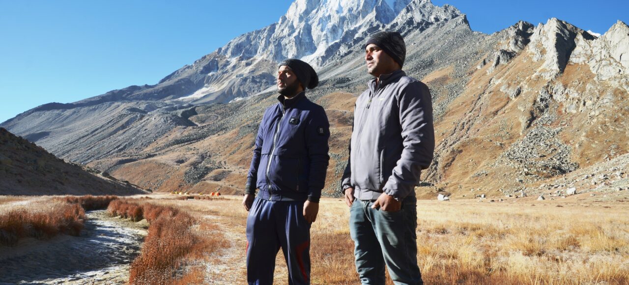
Gaumukh is one of the primary headstreams of the Holy Ganges River which is situated at a height of 12,795 ft. in Uttarkashi District in the state of Uttrakhand. Gaumukh is 18 km from Gangotri Temple in the foothills of Bhagirathi. It is the snout of the Gangotri Glacier. The Bhagirathi River here is pretty speedy. Around the snout, nature presents a wild topography. There are many boulders scattered here and there with some pieces of broken snow, along with the hard clayey snow of the glacier. Little before Gaumukh, the majestic view of Mt. Shivling welcomes the trekkers. 

Geography – : Gomukh, terminus of the Gangotri glacier. The Bhagirathi peaks rise in the background.
Gomukh is 18 km from Gangotri in the foothills of Bhagirathi at a height of 4255m. It is the snout of the Gangotri Glacier.Around the snout, nature presents a wild topography. There are boulders scattered here and there with some pieces of broken snow, along with the hard clayey snow of the glacier.The Gomukh snout is rapidly moving backwards. According to the modern research the snout has moved 1 km in just 70 years.

Best time to visit: May-June and September-October. Expect hiking on the snow at the beginning of May. September and October is a pleasant time to trek here. After October, it is generally not advisable to trek alone due to the extreme cold. After November, expect heavy snow in the area.

Itinerary

Day 1Reach at Gangotri (10,055 ft.); 242 Km drive from Dehradun

StayHotel
Arrive at Gangotri, meet our trek representative/Guide at Gangotri. Check in your hotel. Visit Gangotri Temple for evening aarti and buy trek essential items (if any) from Gangotri market. Dinner and night stay at Hotel in Gangotri.

Day 2Gangotri – Chirbasa - Bhojwasa Trek14 km Stay Camps

Visit the sacred shrine of Goddess Ganga – Gangotri Temple and buy all the necessary items from the market. The trek starts with a decent trail and it remains the same till further 2 km where you need to show permits. As you walk deep into the valley the vegetation also decreases. Continue trekking to reach Chirbasa which is situated 9 kms from Gangotri Town. Cross small streams en route to Chirbasa. Chirbasa is a good campsite and the last point where you’ll see good vegetation. Chirbasa is situated at an elevation of 3580 mts above sea level.

Bhojwasa is located 5 kms from Chirbasa. Bhagirathi Peaks stands high above the ground and is constantly visible during the trek. The trail not only goes through rugged terrains along with the Bhagirathi River but also climbs up to rugged mountains. Bhojbasa is a vast open expanse of land in the valley, situated at an elevation of 3,800 mts above sea level. Camping at Bhojwasa.

Day 3Bhojwasa – Gaumukh Glacier – Bhojwasa/Chirbasa (Trek 10 km Stay Camps)

It takes around 4 to 5 kms to reach closer to Gaumukh Glacier from Bhojwasa. After spending some quality time at Gaumukh, we will return to Bhojwasa. If time permits we can stretch this day to reach Chirbasa as well. Night stay in camps.

Day 4Bhojwasa/Chirbasa - Gangotri

Trek down from Bhojwasa or Chirbasa on Day 4 and try to reach Gangotri by noon. In that case you can continue your journey from
Our trek Service Ends after reaching back to Gangotri

Photos
Map
Package Inclusions & Exclusions

Package Inclusions

1). Accommodation in Gangotri 02 Night
2). All Meals during the Trek
3). Trek Fees, All Trekking equipments (Tents, Sleeping Bags. etc)
4). Porter, Cook & Mule charges (for trekking equipment)
5). Forest Camping Charges, Entry Fees & Permits
6). Mountaineering Certified Guide with Services of Experienced Trek Leader

Package Exclusions

1). Transportation
2). Any other personal expenses
3). Anything not mentioned above Inclusions
4). Taxes Extra
5). Portage of personal bags during the trek
6). Cost of any kind of Travel Insurance.
7). Any Expense of personal nature.
8). Any Expense not specified in the inclusions list.
9). Meals during road journeys

What is cancellation policy?

Cancellations within 15 days prior to departure date – No Refund

5 travellers are considering this tour right now!
whatsapp chat